-

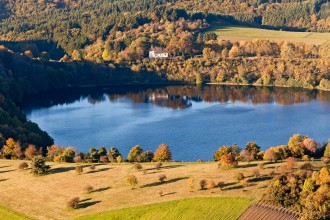
Autumn atmosphere at the Weinfelder Maar with the historic chapel
-

The maar saddle between the Weinfeld and Schalkenmehren maars in the background
-

The highway bridge near Rengen was opened to traffic in 2020, but there is still a gap of 30 km in the A1 in the Eifel region
-

Daun Castle is located above the center of the district town of Daun
-

Today, the Maare-Moselle cycle path leads over the Daun railroad viaduct, which was built from basalt in 1908
-

Eltz Castle consists of eight residential towers grouped around a narrow inner courtyard
-

Eltz Castle towers high above the Eltz as a medieval skyscraper, with the Moselle valley in the background
-

The basalt stone Dronke Tower above the Gemünden maar commemorates the founder of the Eifelverein
-

Three Daun maars: the Gemünden maar in the foreground, the Weinfeld and Schalkenmehren maars behind it
-

View over the rapeseed fields on the main road near Trittscheid
-
The Weinfeld chapel on the "Totenmaar" is the only remnant of a village that was probably destroyed by the plague
-

Pulvermaar near Gillenfeld, in summer gliders use the thermals in the low mountain range
-
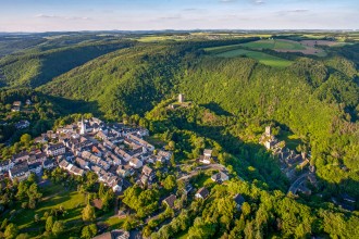
The town of Manderschmeid nestles on the edge of the Liesertal valley
-

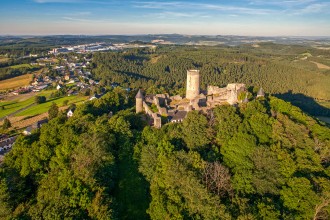
The Oberburg is one of two castles in the Eifel town of Manderscheid on the River Lieser
-

View over the Benedictine Abbey of Maria Laach and Lake Laach
-

The Holzmaar near Gillenfeld is also a nature reserve
-

Wind farm near Kelberg
-

Wind farm near Ormont, Stadtkyll close to the border with Belgium
-
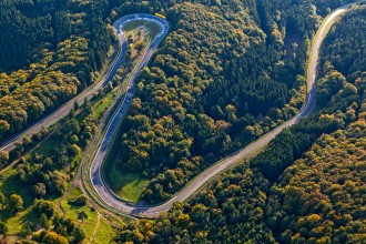
The "Karoussel" is one of the most spectacular sections of the Nordschleife of the Nürburgring's "Green Hell"
-
The Nürburg towers majestically over the Eifel landscape and the maze of bends of the "Ring"
-

The Pulvermaar near Gillenfeld
-

At just 11,000 years old, the Ulmen maar is the youngest north of the Alps
-

The Windsborn crater lake was formed when the Mosenberg crater spewed lava and ash for the last time
-

First hay harvest of the year near Kirchweiler
-

New housing estate for golfers?
-

Freshly mown meadow in the volcanic meadow
-

Moselle bend, vineyards and Cochem Castle
-

And in the south of the Volcanic Eifel: Moselle bend near Bullay and Pünderich
Sky above the Volcanic Eifel (2010)
The idea for this project was born on an ICE train journey in 2008. Two photographers born in the Vulkaneifel region came to the conclusion that an aerial photo book about their homeland was overdue. KaJo and his young colleague Sven Nieder (then based in Bielefeld) were helped by the fact that the district administrator responsible at the time, Heinz Onnertz, was an enthusiastic amateur pilot. He took us up into the air in his open Ikarus C42 ultralight gyrocopter. Up there, we felt like explorers. For over two years, we took every opportunity to get to the Eifel in good flying weather. It didn't always work out, the weather is fickle. The crime legend Jacques Berndorf finally contributed a wonderfully moody text and in 2010 the volume was published by Sven Nieder's newly founded Eifelbildverlag.